
Cruise the History of this Legendary Thoroughfare


U.S. Highway 17 connects coastal homes, commerce, and travelers from Punta Gorda, Fla., north through Georgia, into South Carolina, along the Grand Strand and eventually ending in Winchester, Virginia. Here at home, U.S. 17 is a busy four-to-six lane highway we all take for granted, though “Seventeen Business,” or “Kings Highway,” as local road signs read, hides more history and secrets than might be first imagined.
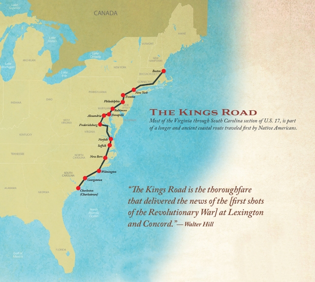
Most of the Virginia through South Carolina section of U.S. 17, some 600 miles, is part of a much longer and ancient coastal route traveled first by Native Americans, then foreign and domestic armies, Federal and Confederate troops, and countless tourists. Long before newly crowned King Charles II ordered its construction around 1660, the road that many of us now travel every day was first a simple footpath.
As those first settlers of the British colonies displaced and pushed the Native Americans west, and with construction underway, the ancient coastal footpath would eventually become the Post Road, Public Road, the King’s Road, the King’s High Road and the Broad Road (among many other names). The mission was to connect Boston to Charleston, a monumental task in any era. It was known as the Old Georgetown Road south of what is now Myrtle Beach.
Commercial and military sea travel between large port cities and other colonial coastal ports was dangerous, so by decree of the king, construction and mapping began in earnest. The Olde Kings Road is widely considered the oldest continuous regional road in America, and it took nearly a century to complete.
Walter Hill, the celebrated Coastal Carolina University and Harvard alumnus, is a historian and director of the Horry County Museum in Conway. He recently reflected on the importance of the route.
“The Kings Road is the thoroughfare that delivered the news of the [first shots of the Revolutionary War] at Lexington and Concord,” he says from his office at the museum. “The news first came to South Carolina at the Boundary House, which was originally located in Little River.”
The Boundary House was a colonial-era home and a public house once located near present day U.S. 17 and Heather Lakes Drive in Little River. Isaac Marion, big brother to the Swamp Fox, Francis Marion, lived there when the news came through. Dispatches were immediately sent south, all the way to Charles Town, which became Charleston in 1783.
“[The Kings Road] has been a thoroughfare of travel, trade and communication since before the founding of this country,” Hill continues.
New Englanders know the Kings Road as “The Post Road” from Massachusetts to Connecticut and New York. Other coastal regions have their own names for the old Kings Road which connects nearly every major city and strategic port on the east coast—Boston, Mass., New York City, Philadelphia, Pa., greater Washington D.C., Norfolk, Va., Baltimore, Md., Virginia Beach, Va., Wilmington, N.C., Georgetown S.C. and Charleston, S.C. Later it connected Charleston to Savannah, Ga.
The “completed” road, around 1750, was hardly the nicely paved (ignore the potholes) route we know today. There were hazards on nearly every one of its 1300 miles with the South Carolina section particularly detested by travelers of the day. The rural sections were little more than dirt or sandy paths through wilderness just wide enough for the horse-drawn carriages to pass. After moderate rains parts of the road became a twenty foot wide river of mud. It was made even more treacherous when the mud dried and hardened in the sun, leaving rigid, deep grooves just the perfect size to snap wagon wheels and horses’ limbs. Unreliable ferries, rickety bridges and tree stumps were only a part of the problem. In the continuously wet lowlands, trees were felled and connected in a perpendicular orientation across the road. This made for a bumpy but passable carriage ride, giving portions of the kingly route the nickname “the corduroy road.” Swamps, sandy overwashes, nearly impassable inlets, bandits, and more meant the route was at best a treacherous and difficult alternative to traveling the east coast by boat. But time marched on…
Presidential Visits
After the British were sent packing at the conclusion of the War for Independence, a few years later, newly elected President George Washington embarked on his famed “Southern Tour,” which included local stops in what is now Little River, North Myrtle Beach, Myrtle Beach, Murrells Inlet, Georgetown and McClellanville.
On March 21, 1791, eight men, at least two of whom were slaves, and 11 horses plus Washington’s carriage, set out along the Great Coastal Road from Philadelphia, traveling 25 to 40 miles each day. His preferred “traveling gate,” was “5 miles an hour,” according to his own pen. On April 27, 1791, Washington, who kept meticulous diaries, was “entertained (& very kindly) without being able to make compensation,” after he overnighted at “Mr. Vareen’s” home. A part of the broader 400-acre Vereen indigo plantation now gone, only the Vereen Memorial Historical Gardens in Little River remains. Vereen also owned property in what is now the Windy Hill area of North Myrtle Beach. Archivists reference Washington crossing the Lewis Swash (now the Singleton Swash near The Dunes Club in Myrtle Beach) at low tide and spent the day cruising the beach before stopping. The next day they made it to Mr. Pawley’s residence for dinner in what is assumed to be the Surfside Beach area. Later that day the party stopped and stayed at Dr. Henry Flagg’s residence to sleep. Flagg, a Revolutionary War surgeon, owned a plantation and home in what is now Brookgreen Gardens. In the next days, Washington’s entourage went through what is now Hobcaw Barony and along the Old Georgetown Road to Hampton Plantation just outside of McClellanville. The plantation later became home to Archibald Rutledge, the first poet laureate of South Carolina, and is now a state park.
The very same route whose construction was ordered by the British monarch King Charles II, was the same route used to deliver the news to revolutionaries in the all-important South Carolina colony. This same route would later convey the new U.S. president on his visitations of the former British colonies, thanks to our former king.
Over the centuries, the King’s Road widened and transformed as more and more settlements took root along its course. These settlements became towns, towns became cities, and what began as a simple passage became a lifeline—one that millions now rely on to traverse the coastal region.
Here in Horry and Georgetown counties, Kings Road (commonly called The Kings Highway) and portions of U.S. 17 were not paved until around 1940. Though the modern road bears little resemblance to the original, just south of Myrtle Beach, and a few miles north of North Myrtle Beach, portions of the original Kings Road (or Broad Road) in its close-to-original condition can be found with a little sleuthing and the help of GPS.
Time Travel
It only takes a small leap of imagination for thoughts to drift backward through the centuries. A visit to a few of the surviving stretches of the old Kings Road is enough to summon the past to life, where small sections of the ancient route endure much as they once did.
Built in 1768, The St. James Episcopal Church sits within the Francis Marion National Forest, just over an hour south of Myrtle Beach. The church sits proudly on a long stretch of the Old Kings Road (the Old Georgetown Road) and remains essentially unchanged from the mid-1700s. The church and the dirt road itself are both protected and on the National Register of Historic Places. Less than a mile away, the Hampton Plantation, completed around the same time the Old Kings Road was declared finished, stands as testament to the old plantation era when rice ruled the South Carolina lowcountry. Washington stopped at the plantation and was asked about a tree planted in front of the big house. “Should it stay or go?” asked Harriet Pinckney Horry on May 1, 1791. Washington reportedly answered “Let the tree stand,” and so it did. The tree was dubbed “The Washington Oak,” in his honor and is estimated to be around 270 years old.
At the Vereen Memorial Historical Gardens in Little River, traces of the abandoned roadbed are being restored to their 18th century conditions at 2250 SC-179, Little River and are a part of the Gardens’ popular walking trails. This stretch of the old road sits within 50 feet of the current U.S. 17.
Historians agree that modern U.S. 17 and the Grand Strand’s Kings Highway do not perfectly line up with the original Kings Road. Portions of the original may have run up to many miles west of the roads we now travel, while other portions were due east, even closer to the shoreline. It’s likely that the easternmost coastal road, known as Outboard Lane and U.S. 17 Bus. in Murrells Inlet, home to the Marsh Walk, was routed over the original old Kings Road, but details are sketchy. Another north/south route just west of U.S. 17 in Murrells Inlet is named the “Old Kings Hwy,” which may also share some of the original route’s footprint.
The longest original stretches open to public visitation may be at the 16,000-acre Hobcaw Barony. Some five miles of the old road wind through the woods and scrubby underbrush, ending at the water’s edge. Here, a ferry would have taken passengers, horses and carriages across the Winyah Bay to Georgetown.
Regardless of its exact location and under numerous names, the Old Kings Road, all 1300 miles of it, calls out to the curious.
Here along the Grand Strand, one only needs to listen through the traffic noise and the motorcycle mayhem, to hear the echoes of the colonial era and further back when failed would-be Spanish colonizer Lucas Vasquez de Ayllon established the first known settlement in the New World around 1526. His party first arrived in what would become Georgetown, though no archaeological evidence has been discovered. Ships’ logs and survivors’ tales, however, confirm the basic facts.
Two centuries later, in the early 1700s, Blackbeard would visit the Grand Strand and possibly drag his ill-gotten booty ashore around Murrells Inlet or Little River, which provided safety and shelter from the open seas and British gunboats. While on land he and his buccaneers would have traversed the Old Kings Road, which by then was nearly complete.
All of these early settlers, colonizers, swashbucklers, and rogues (and even our first president) traveled the routes we still travel today, but prior to their arrival, ancient Native Americans padded softly through the woods to the shoreline, where they feasted on shellfish and basked in the warm water of Long Bay.